|
Air Monitoring and
Surveillance Camera Site Locations
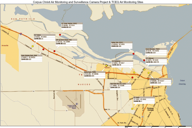
| The red flags on the map below
represent the locations of the 7 monitoring sites. Choose
a location and click the flag to view more details.
The details include various maps, and site photos. |

Click here to view larger map
Schedule of Air Monitoring Sites,
Locations and Major Instrumentation
|
Contract Ref |
TCEQ CAMS# |
Description of Site Location |
Monitoring Equipment |
|
Auto GC |
Event Mon |
Sulphur Com |
Met Station |
Camera |
|
1.a |
634 |
Oak Park Recreation Center |
Mar 2005 to date |
C: Dec 2004 to Feb 2012
T: Dec 2004 to Apr 2012 |
|
Dec 2004 to
date |
|
|
1.b |
629 |
Grain Elevator @ Port of Corpus Christi |
|
T&C: Dec 2004 to date |
Dec 2004 to
date |
Dec 2004 to
date |
|
|
1.c |
630 |
J. I. Hailey Site @ Port of Corpus Christi |
|
T&C: Dec 2004 to date |
Dec 2004 to
date |
Dec 2004 to
date |
|
|
1.d |
635 |
TCEQ Monitoring Site C199 @ Dona Park |
|
T&C: Dec 2004 to date |
Dec 2004 to
date |
Dec 2004 to
date |
Jan 2005 to date |
|
1.e |
631 |
Port of Corpus Christi on West End of CC Inner Harbor
(Inactive May 15, 2012) |
|
T&C: Dec 2004 to May 2012 |
Dec 2004 to
May 2012 |
Dec 2004 to May 2012 |
|
|
1.f |
632 |
Off Up River Road on Flint Hills Resources Easement |
|
T&C: Dec 2004 to date |
Dec 2004 to
date |
Dec 2004 to
date |
|
|
1.g |
633 |
Solar Estates Park at end of Sunshine Road |
Yes |
C: Dec 2004 to Feb 2009
T: Dec 2004 to Apr 2012 |
Dec 2004 to
date |
Dec 2004 to
date |
Jan 2005 to date |
UT and TCEQ Monitoring
Sites
Click
here to view larger map of UT & TCEQ sites
|