|
Participants | Visitors | Home |
|
|||||||||||||||||||||||
|
|
|||||||||||||||||||||||
| News | ||
| About | ||
| Background
Scientific Data |
||
| Study Sites | ||
| Logistics | ||
| Daily Plan-It | ||
| Activities | ||
| Photos | ||
| Data Archive | ||
| Forecast | ||
| Measurements | ||
| Aircraft | ||
| Participating Organizations | ||
| Related Links | ||
 |
||
| Aircraft > General Approach Information | |||||
|
TNRCC/Baylor
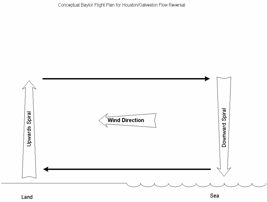
Aircraft Flight Plans Land-Sea/Bay Breeze
Investigation All flights to and from target areas should be flown as near surface as possible- typically at altitudes of about 500 to 2,000 feet - the air layer of interest will be close to ground (under 1,000 feet). The morning pattern 0700- 1000 (land breeze characterization) will consist of a series of shallow vertical profiles (from close to surface to the top of the air layer of interest) both on shore and off shore. The afternoon pattern 1300-1700 (sea/bay breeze characterization) will consist of an offshore vertical spiral from (from close to surface to the top of the air layer of interest) followed by a traverse inland (between 5 to 15 miles) to identify the land-sea breeze frontal boundary. Traverses will be flown perpendicular to the frontal boundary at intervals of about 5 to 10 miles. Traverses will extend 5 miles to either side of the boundary until the area of interest has been covered.
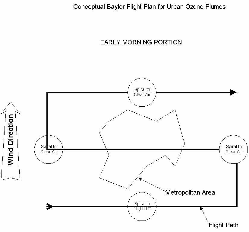
Urban Plume Circle area to investigate background levels and to look for signs of plume orientation Fly parallel traverse pattern perpendicular to estimated and/or measured urban plume orientation Traverses should be about 5 to 10 miles apart Traverses should be long enough to show background levels on both sides of the urban plume Traverses should be continued downwind until the peak plume ozone levels are below 85-125 ppb or background concentrations, whichever is higher. Fly one spiral on the upwind side of the area and at least one spiral near the area of maximum ozone
Large Industrial Plume Circle the facility to investigate background levels and to look for signs of plume orientation Fly parallel traverse pattern perpendicular to estimated and/or measured industrial plume orientation Traverses should be about 3 to 6 miles apart (adjust to correspond with an estimated distance of transport in one hour based on prevailing wind speed) Traverses should be long enough to show background levels on both sides of the urban plume Traverses should be continued downwind until the plume can no longer be detected Fly a vertical profile pattern at intervals of 10 miles from the facility Each vertical profile will consist of a series of traverses over the same geographical area but at different altitudes. The lowest traverse should be at about 1,000 feet above ground level. Additional traverses should be flown at increments of 1,000 feet above the previous traverse until the plume is no longer detected on the last traverse (plane is above the mixing layer). A Chanendell turn (180 degree turning climb) can be performed to transition between traverses. Regional Background
Investigation All flights to and from target areas should be flown well below the mixing height - typically at altitudes of about 2,000 to 3,000 feet - for purposes of documenting regional background levels between Waco and the flight destination. One flight pattern will be dedicated to investigating regional background levels This pattern will consist of a series of parallel traverses covering the region of interest Traverses will be flown perpendicular to the regional air flow pattern Traverses will be flown at intervals of about 50 to 100 miles, depending on traverse length.
__________________________________________________________
|
|||||
|
|
|
|
This site created by the Instructional Media Lab |